Chile and Argentina, satellite image (E070/0600) Kids T-Shirt
South American Kids T-Shirt
designed and sold by SciencePhoto
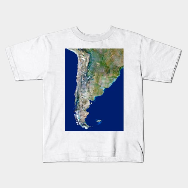
Chile and Argentina, satellite image. North is at top. Chile is a long country which occupies the strip of land between the Pacific coast and the Andes mountains in the west of South America. Argentina extends east from Chile to the Atlantic coast. The border between Argentina and Chile follows the Andes mountain range. These mountains extend the entire length of western south America. The most southerly tip of South America, Cape Horn, lies within the Tierra del Fuego archipelago. The Falkland Islands lie further to the east, they are an oversees territory of the UK, although sovereignty is claimed by Argentina.

More Chile and Argentina, satellite image (E070/0600) Products
People Love TeePublic!
Not what you're looking for?
Try another search.

Product Quality
Our Production Team establishes the highest quality standards for third-party printers who participate in the marketplace to ensure that every product sold is perfect.

South American Kids T-Shirt FAQ
UPS MI Domestic (6-8 Business Days)
FedEx 2-Day (4-6 Business Days)
Estimates include printing and processing time.More Shipping Info
We want you to love your order! If for any reason you don't, let us know and we’ll make things right.Learn More
Similar to Chile and Argentina, satellite image (E070/0600) Kids T-Shirt
More South American products
Customers Also Search
More content to explore
Artist's Applied Tags
Trending Tags
The links above have been automatically generated based on tag usage by third-party designers on the TeePublic platform.