Antique map of New York City from 1840 featuring Manhattan, New York Harbor, the Hudson River, Jersey City, Brooklyn, Williamsburg, the East River or Strait of the Sound.
Tags:
antique map, brooklyn, city map, east river, hudson river
Antique old world map featuring the Americas by Nicolaes Visscher, 1658. The map shows North and South America, California as an island and Greenland at the top. The upper cartouche is a dedication for Cornelius Witsen. Novissima et accuratissima totius Americae descriptio per Nicolaes Visscher.
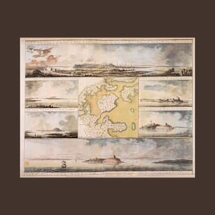
View of Boston, the Capital of New England from Colonel Hatch's house on the road to Dorchester by William Pierie, 1773. View from Dorchester Neck, View of Castle William at Station C, View from Charlestown, View of Castle William at Station D, View of Castle William.
Tags:
antique maps, boston harbor, castle william, charlestown, colonel hatch
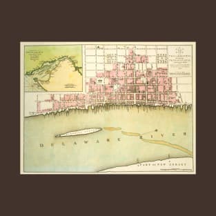
A Plan for the City of Philadelphia, the Capital of Pennsylvania from an actual survey by Benjamin Easburn, Surveyor General, 1776. An insert has a chart of Delaware Bay and River.
Tags:
antique maps, cartographers, cartography, delaware bay, delaware river
Antique map of Berlin, Germany by Matthäus Seutter, 1738 emphasizes the military aspect of Berlin. Over the River Spree is a fortress designed by Johann Gregor Memhardt. The castle walls are prominent in the view of the city from the east. The portrait of King Friedrich Wilhelm I of Prussia is surrounded by military trophies, a cannon and drums.
Tags:
antique maps, germany, king friedrich wilhelm i, maps, old world map
Antique old world map woodblock print of Nagasaki Harbor by Bunkindō from 1821 featuring the streets, temples, shrines, lakes and harbor of Nagasaki. In the harbor, ships from foreign countries are identified, namely ships from China and Holland. The location of the foreign colonies of Holland and China are also identified.
Lucas Janszoon Waghenaer’s General Sea Chart of Europe (Generale pascaerte van Europa), first published in 1583, is the earliest printed sea chart of Europe. It covers Western and Northern Europe. Universe Europae Maritime Eiusque Navigationis Descritio. Embellished with sailing ships, compass roses, coats of arms, etc.
Tags:
atlantic, baltic, barents sea, britain, compass rose
Antique bird's eye view city plan of Moscow, Russia by Joan Blaeu, 1662. The map is oriented to the West with a key to locations. Carstvajuscoi Grad Moskva Nacal'noi Gorod useh Moskovskih Gosudarstu ... Urbis Moskvae.
Antique aerial view of St. Petersburg, Russia, 1878 by William Collins, Sons & Company. The view of St. Petersburg is oriented south with Peter and Paul fortress near the center within the Neva River. St. Petersburg was the capital of the Russian Empire until it would be moved to Moscow in 1918.
Tags:
aerial map, antique map, birds eye view, city map, neva river
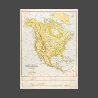
Antique old world map from 1705 featuring North America by Pieter van der Aa. The map features California as a peninsula, New Mexico, parts of Canada, Greenland, the Gulf of Mexico, the Caribbean and Central America. Neptune and two Native Americans flank the large title cartouche. The routes of the explorers Cortez, Drake and Olivier are shown in the Pacific. L'Amerique Septentrionale Suivant les Nouvelles Observations de Messrs. de l'Academie Royale des Sciences, etc
Antique old world map of Asia by Gerardus Mercator, 1613. Asia ex magna orbis terre descriptione Gerardi Mercatoris desumpta studio et industria G.M. Iunioris.
Antique old world map of Europe by Gerard and Rumold Mercator, 1595 includes an elegant cartouche in the lower right corner. Europa, ad magnæ Europæ Gerardi Mercatoris P. imitationem / Rumoldi Mercatoris F. cura edita ; servato tamen initio longitudinis ex ratione magnetis, quod Pater in magna sua universali posuit.
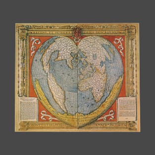
A Modern and Complete Map of the World by the Royal Mathematician Oronce Fine of the Dauphiné, 1534. Orontius Finnaeus. Recens et integra orbis descriptio. Orontius F. Delph Regi mathematic facebiat
Bernhard von Breydenbach made a pilgrimage to the Holy Land in 1483. The country is seen from the west (with a pilgrim's vessel near the coast at Jaffa) towards the east. Jerusalem is seen from The Mount of Olives westward, since this is the best viewing angle of the Holy City.
Tags:
antique map, bernhard von breydenbach, breydenbach, holy land, israel
Antique Map of the Americas by John Speed, 1626. America with those known parts in that unknowne worlde both people and manner of buildings discribed and inlarged by John Speed, 1626.
The Story of Exodus on Willem Janszoon Blaeu's Antique Map of the Holy Land, 1629. The map shows the aftermath of Moses and the children of Israel crossing the Red Sea, with Moses atop a rock at the right, watching the closing of the Sea and Pharaoh's army's inundated. A scene shows the encampment at the foot of Mount Sinai, with Moses in the glow of the burning bush, receiving the Ten Commandments. Terra Sancta quae in Sacris Terra Promissionis Olim Palestina
Tags:
antique maps, cartographers, cartography, exodus, israel
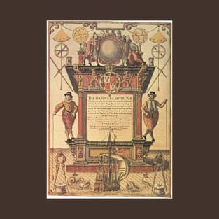
Frontispiece for 'The Mariner's Mirror' written by Lucas Jansz Waghenaer, 1588. An atlas of nautical charts and sailing directions with instructions for navigation. It was the first of its kind in the history of maritime cartography. A sea-atlas comprised charts, sailing directions, coastal views and navigational tables of the European coasts from Gibraltar to North Cape.
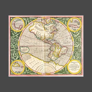
Antique map of the Western Hemisphere featuring the Americas originally made by Michael Mercator in 1595. America sive India Nova. The inserts show Cuba, Haiti and the Gulf of Mexico. Acanthus leaves surround the map.
Antique Old World Map by Joan Blaeu, c. 1630. The Nova Totius Terrarum Orbis Geographica Ac Hydrographica Tabula or “A New Geographic and Hydrographic Depiction of All the Lands of the World” was created by Willem Blaeu in Amsterdam in 1630.
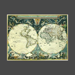
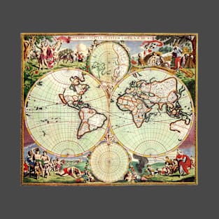
Antique old world double hemisphere map by Joan Blaeu, 1662. Nova Et Accuratissima Totius Terrarum Orbis Tabula. Auctore Ioanne Blaeu. Featuring allegorical figures along the bottom depicting the four seasons, celestial figures along the top, and portraits of the astronomer Galileo Galilei in the upper left and Tycho Brahe in the upper right.
Nova Orbis Tabula in Lucem Edita by Frederick de Wit, c. 1665. Antique old world map featuring a double hemisphere with two polar projections and scenes of the four seasons and signs of the zodiac in the corners.