- Adult Apparel
- T-Shirts
- Tank Tops
- Hoodies
- Crewneck Sweatshirts
- Long Sleeve T-Shirts
- Baseball T-Shirts
- Kids Apparel
- Kids T-Shirts
- Kids Hoodie
- Kids Long Sleeve T-Shirt
- Home Goods
- Wall Art
- Mugs
- Pillows
- Totes
- Tapestries
- Pins
- Cases & Stickers
- Phone Cases
- Stickers
- Magnets
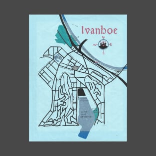
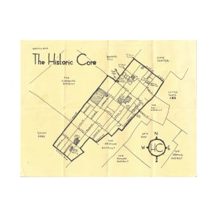
Ivanhoe was a community located just north of Los Angeles, so named by Scottish-born Mexican Hugo Reid (although it was also known as "Ivanhoe Town." Reid died in 1852. Ivanhoe was surveyed and mapped in 1887. Many of the street names were taken from Sir Walter Scott's novel or simply referenced Scotland. Ivanhoe remained on most maps until the 1920s when it was largely subsumed into the 20th century community of Silver Lake.
Tags: california, los angeles neighborhoods, la, hand drawn map, los angeles neighborhood map
Ivanhoe
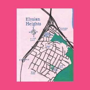
I painted this map of Elysian Heights for a show I called "Taste of the Mideast Side" in which I exhibited maps of various neighborhoods in the Mideast Los Angeles region. The gray cat in the compass rose is "Room 8" -- an internet celebrity cat who was world-famous before there was an internet.
Tags: hand drawn maps, los angeles neighborhood maps, maps, geography, cartography
Elysian Heights
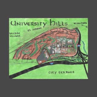
University Hills is the name of the small, hilly Los Angeles neighborhood dominated by the campus of California State University, Los Angeles. It's also home to the city's tallest public stairway, though... and some other stuff. I explored in 2014 on a dog walk for my series, "California Fool's Gold." https://ericbrightwell.com/2014/01/08/as-i-look-back-on-my-education-exploring-university-hills/
Tags: los angeles, la, art maps, hand drawn maps, the eastside
University Hills

Altadena is an unincorporated community located in the foothills and flats beneath the San Gabriel Mountains in the San Gabriel Valley. I explored and mapped it in 2012 for my series, "California Fool's Gold." https://ericbrightwell.com/2012/07/17/california-fools-gold-exploring-altadena-the-community-of-the-deodars-2/
Tags: los angeles neighborhood map, la neighborhood, the 626, los angeles, los angeles neighborhoods
Altadena
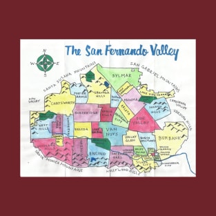
I wrote a primer and mapped the San Fernando Valley, or simply, "The Valley," for "California Fool's Gold" in 2012. This watercolor map, however, dates to 2013 or so (when I experimenting with watercolors). It is primarily a region of the city of Los Angeles but also includes the municipalities of San Fernando and Burbank, as well as the unincorporated community of Universal City. https://ericbrightwell.com/2012/11/05/california-fools-gold-a-san-fernando-valley-primer/
Tags: geography, cartography, los angeles neighborhoods map, la neighborhoods, maps
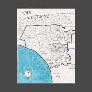
An ink and correctional fluid map of Los Angeles's Westside region. It's home to enclaves like Little Brazil, Little Britain, Little Odessa, Little Osaka, and Tehrangeles; UCLA; world-famous Venice Beach, and a handful of places with "Beverly" in their name. I wrote a primer about the communities of the Westside for "California Fool's Gold." https://ericbrightwell.com/2011/08/18/california-fools-gold-a-westside-primer/
Tags: los angeles neighborhoods map, la neighborhoods, la neighborhood map, cartography, art maps
The Westside
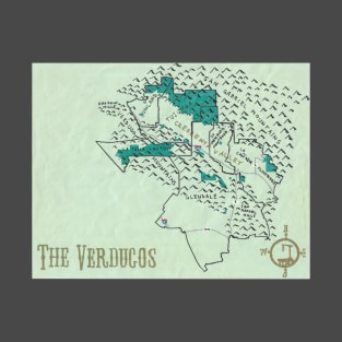
An oil paint map of the Verdugos region, which is comprised of Glendale, Flintridge, La Cañada, La Crescenta, La Tuna Canyon, Montrose, Sunland, and Tujunga. The Verdugos Mountains extend into Burbank but, come on, that community is a San Fernando Valley town. I wrote a primer on the region and its communities for "California Fool's Gold." https://ericbrightwell.com/2011/04/14/california-fools-gold-a-verdugos-primer/
Tags: tujunga, geography, la canada, la crescenta, glendale
The Verdugos
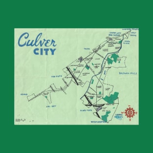
Painting: Oil, Ink on Paper. In 2013, I explored the community of Culver City for my series, "California Fool's Gold." Culver City is a municipality in the Westside region of Los Angeles. You can read the piece, which includes this map, here: https://ericbrightwell.com/2013/09/18/all-roads-lead-to-culver-city-exploring-the-heart-of-screenland/
Tags: westside, la neighborhoods, los angeles neighborhoods, the westside, outsider art
Culver City
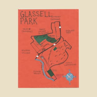
Back in 2014, I explored the Northeast Los Angeles neighborhood of Glassell Park. I made this map with ink and oil paint; and included it in a piece for my series, "California Fool's Gold." https://ericbrightwell.com/2014/08/05/breadbaskets-and-head-gaskets-exploring-glassell-park/
Tags: the eastside, los angeles, northeast los angeles, nela, glassell park
Glassell Park
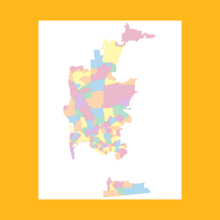
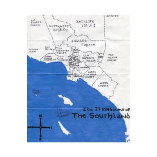
I moved to Southern California in 1999. I couldn't find a map of all of the neighborhoods of San Diego. I set about making my own -- exploring the vast county on foot and mass transit. Along the way, I drew maps with ink and painted them in watercolors and oil paint -- or some combination (including correction fluid). As a lefty converted to a righty, my handwriting is terrible and my maps are sometimes hard to read when reproduced or reprinted -- and so I've made these clean, digital versions for people who prefer that sort of thing.
Tags: san diego maps, sd, neighborhoods, san diego neighborhoods, san diego
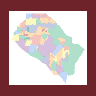
I moved to Southern California in 1999. I couldn't find a map of all of the communities and neighborhoods of Orange County. I set about making my own -- exploring the vast county on foot and mass transit. Along the way, I drew maps with ink and painted them in watercolors and oil paint -- or some combination (including correction fluid). As a lefty converted to a righty, my handwriting is terrible and my maps are sometimes hard to read when reproduced or reprinted -- and so I've made these clean, digital versions for people who prefer that sort of thing.
Tags: neighborhood maps, maps, outsider art, art maps, orange county neighborhoods
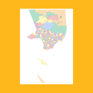
I moved to Los Angeles in 1999. I couldn't find a map of all of the communities and neighborhoods of the county. I set about making my own -- exploring the vast county on foot and mass transit. Along the way, I drew maps with ink and painted them in watercolors and oil paint -- or some combination (including correction fluid). As a lefty converted to a righty, my handwriting is terrible and my maps are sometimes hard to read when reproduced or reprinted -- and so I've made these clean, digital versions for people who prefer that sort of thing.
Tags: neighborhoods, geography, los angeles, neighborhood map, la
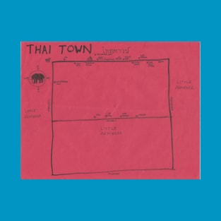
An ink map that I made of Thai Town for "California Fool's Gold" in 2010. It may be the only map that I made which is not at all to scale. https://ericbrightwell.com/2010/04/05/california-fools-gold-exploring-thai-town-%E0%B9%84%E0%B8%97%E0%B8%A2%E0%B8%97%E0%B8%B2%E0%B8%A7%E0%B8%99%E0%B9%8C-on-songkran/
Tags: hand drawn maps, art maps, la neighborhoods, map, cartography
Thai Town
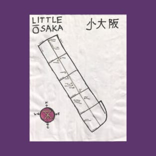
An ink and oil paint map of Little Osaka (now officially re-named "Sawtelle Japantown") that I made for "California Fool's Gold" in 2009. It got a little wrinkled because it was raining during the exploration. https://ericbrightwell.com/2009/12/09/california-fools-gold-exploring-little-osaka-%E3%83%AA%E3%83%88%E3%83%AB%E5%A4%A7%E9%98%AA/
Tags: osaka, los angeles westside, neighborhoods, japan, soteru
Little Osaka
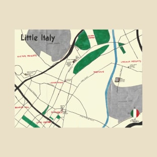
A map I made showing the vestiges of Los Angeles's historic Little Italy in 2013 for "California Fool's Gold." Since then, Little Joe's -- the last remaining Italian restaurant in the neighborhood -- has been demolished. https://ericbrightwell.com/2013/07/10/exploring-the-remains-of-l-a-s-little-italy-block-by-block-land-of-sunshine-kcet/
Tags: san antonio winery, los angeles neighborhoods, casa italiana, la neighborhoods, italians
Little Italy
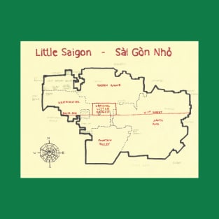
An ink map that I made of the greater Little Saigon and official Little Saigon region and neighborhood in North Orange County for "California Fool's Gold" in 2014. https://ericbrightwell.com/2014/05/14/visiting-little-saigon-happy-asian-pacific-american-heritage-month/
Tags: bolsa, garden grove, maps, cartography, orange county
Little Saigon
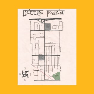
An ink and correctional fluid map of the Little India neighborhood in Southeast Los Angeles that I made for "California Fool's Gold" in 2011. https://ericbrightwell.com/2011/05/20/california-fools-gold-exploring-little-india/
Tags: los angeles, cartography, southeast los angeles, map, la neighborhoods
Little India
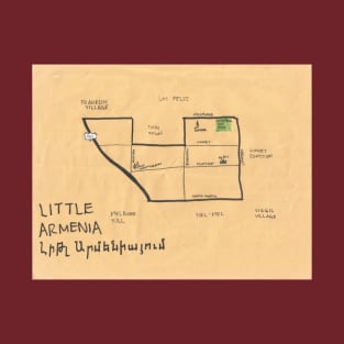
An ink and correctional fluid map that I made of Hollywood's Little Armenia neighborhood in 2008 for "California Fool's Gold." https://ericbrightwell.com/2008/10/07/california-fools-gold-exploring-little-armenia/
Tags: geography, la neighborhoods, cartography, armenia, los angeles
Little Armenia
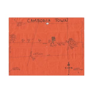
An ink and correctional fluid map that I made of Long Beach's Cambodia Town neighborhood for "California Fool's Gold" in 2010. https://ericbrightwell.com/2010/05/25/california-fools-gold-exploring-cambodia-town-%E1%9E%91%E1%9E%B8%E1%9E%80%E1%9F%92%E1%9E%9A%E1%9E%BB%E1%9E%84%E1%9E%81%E1%9F%92%E1%9E%98%E1%9F%82%E1%9E%9A-long-beachs-little-phnom-penh/
Tags: long beach, cambodia, khmer, maps, hand drawn maps
Cambodia Town
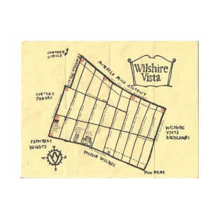
An ink map of the Midtown Los Angeles neighborhood of Wilshire Vista that I did for "California Fool's Gold." https://ericbrightwell.com/2018/09/07/california-fools-gold-exploring-wilshire-vista/
Tags: los angeles, la, socal, los angeles neighborhoods, midcity
Wilshire Vista
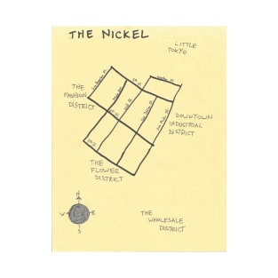
An ink map that I made of Skid Row for "California Fool's Gold." It's titled "The Nickel," because that's what some people refer to the neighborhood as since it's centered on 5th Street. https://ericbrightwell.com/2010/10/25/califoronia-fools-gold-exploring-skid-row-hells-half-acer-aka-the-nickel/
Tags: california, so cal, downtown la, la, downtown los angeles
The Nickel
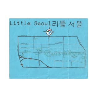
A hand-drawn map I made of Orange County's Little Seoul, a fairly small Korean enclave in Garden Grove -- and yet nevertheless one of the largest Korean enclaves in the US. https://ericbrightwell.com/2014/05/20/visiting-orange-countys-little-seoul-happy-asian-pacific-american-heritage-month/
Tags: the korean business district, north orange county, cartography, hand drawn maps, orange county
Little Seoul

A map I did of the Midtown region of Los Angeles. https://ericbrightwell.com/2011/07/14/california-fools-gold-a-midtown-primer/
Tags: map art, cartography, hand drawn maps, art maps, k town
Midtown
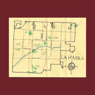
An ink map of La Habra, a suburb in North Orange County that I explored for "California Fool's Gold" in 2019. https://ericbrightwell.com/2019/06/02/california-fools-gold-exploring-la-habra/
Tags: folk art, outsider art, art maps, north orange county, orange county
La Habra
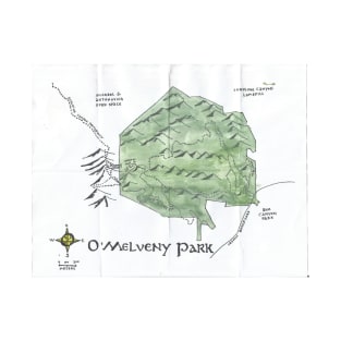
O'Melveny Park, in the Granada Hills neighborhood, is one of Los Angeles's largest but least known parks. From within the park one can climb to the top of Mission Point, the second highest peak in the Santa Susana Mountains.
Tags: maps, cartography, geography, map art, art maps
O'Melveny Park
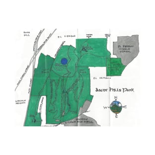
Ascot Hills Park, in the El Sereno neighborhood, is a modest park in Los Angeles's Eastside -- but one of my favorites. It doesn't have much shade but makes up for it with a subtle charm -- rolling hills, nice views of the city, and mysteriously attractive radio towers. https://ericbrightwell.com/2015/03/25/southland-parks-visiting-ascot-hills-park/
Tags: art maps, geography, el sereno, the eastside, maps
Ascot Hills Park
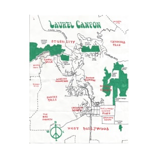
I explored Laurel Canyon for "California Fool's Gold" back in 2009. However, I was unsure of how to represent a neighborhood the borders of which are formed by mountains rather than streets; therefore, several years passed before I got around to painting this oil painting map.
Tags: laurel canyon, los angeles, map, geography, art maps
Laurel Canyon
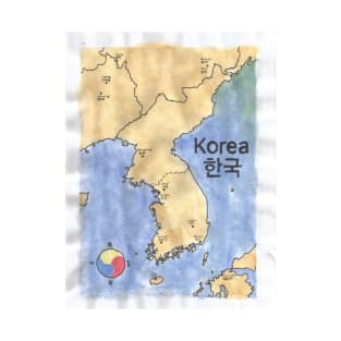
In 2017, I visited Korea for the first time. I spent most of the vacation in Seoul and Busan. This is the watercolor map that I made to commemorate the trip.
Tags: korea, maps, cartography, art maps, map art
Korea
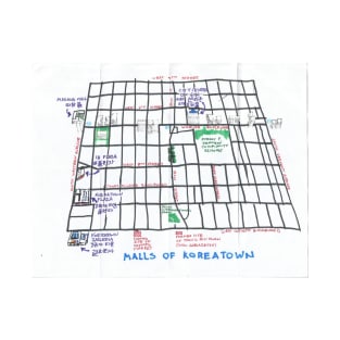
In 2017, on the tenth anniversary of exploring Los Angeles neighborhoods as "California Fool's Gold," I went on a few explorations accompanied and suggested by friends. My friend Machiko suggested that we explore the malls of Koreatown, which I thought was a great idea. https://ericbrightwell.com/2017/07/20/urban-rambles-exploring-koreatown-malls-with-machiko/
Tags: cartography, los angeles, geography, hand drawn maps, maps

Imperial County, along with San Diego County, comprises California’s Southern Border Region but their similarities pretty much end there. Whereas the presidio at San Diego was established by the Spanish in 1769 and is the oldest European settlement in the state. On the other hand, Imperial County, created in 1907, is California’s newest. Whereas San Diego County is the second most populous county in California, Imperial County is the least. San Diego’s climate is characterized as chaparral, Imperial County is located within the Colorado Desert. But yes, both counties lie just north of the Estado Libre y Soberano de Baja California. https://ericbrightwell.com/2015/04/28/california-fools-gold-an-imperial-county-primer/
Tags: imperial county, hand drawn maps, art maps, cartography, so cal
Imperial County
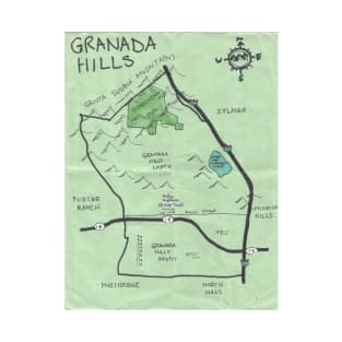
Granada Hills was the first Los Angeles neighborhood that I explored for "California Fool's Gold." I didn't actually get around to sketching a map until after the maps that I made subsequently began to garner positive press. Then, ten years after first visiting, I returned at night to explore again and made a few additions. https://ericbrightwell.com/2007/10/30/granada-hills/ https://ericbrightwell.com/2007/10/30/granada-hills/
Tags: maps, hand drawn maps, granada hills, the valley, art maps
Granada Hills
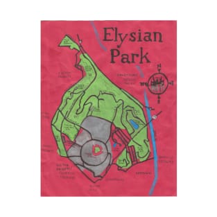
The first map that I drew after moving to Los Angeles was of Elysian Park. I'm not sure what happened to that original one but this is a later one that I made. Initially, I used ink for the green section (as I did silver with the Dodger Stadium parking lot) but it looked muddy so I later went back and painted it with oil pain. https://ericbrightwell.com/2018/10/01/southland-parks-visiting-elysian-park/
Tags: cartography, geography, los angeles, map art, los angeles neighborhoods
Elysian Park
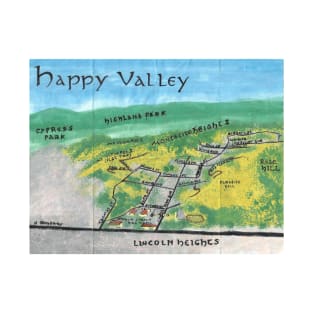
This was the first watercolor map that I did -- and the first bird's eye view map. I was inspired by some 19th-century bird's eye view maps that I'd been looking at, some East Asian landscape art, and the fact that Happy Valley's neighborhood borders are formed more by hills than streets.
Tags: los angeles, watercolor, lincoln heights, map, hand drawn maps