- Adult Apparel
- T-Shirts
- Tank Tops
- Hoodies
- Crewneck Sweatshirts
- Long Sleeve T-Shirts
- Baseball T-Shirts
- Kids Apparel
- Kids T-Shirts
- Kids Hoodie
- Kids Long Sleeve T-Shirt
- Home Goods
- Wall Art
- Mugs
- Pillows
- Totes
- Tapestries
- Pins
- Cases & Stickers
- Phone Cases
- Stickers
- Magnets


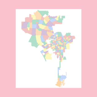
The Semi-Tropic Spiritualists were a group of mediums and clairvoyants who held midnight dances at their Semi-Tropic Park, in the Elysian Heights/Echo Park area between 1905 and 1910. https://ericbrightwell.com/2023/10/11/houses-of-the-hallows-the-semi-tropic-spiritualists-and-the-semi-tropic-park/
Tags: art maps, cartographic art, cartography, echo park, elysian heights
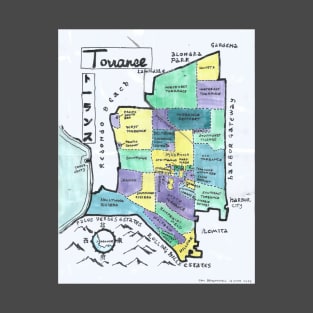
June 2023, I explored Torrance, made a map, and wrote about it here: https://ericbrightwell.com/2023/06/15/california-fools-gold-exploring-torrance/
Tags: art maps, california, cartography, japanese, japantown
Torrance
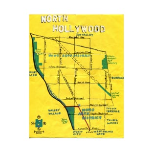
An oil paint map of North Hollywood that I made for "California Fool's Gold" in 2014. https://ericbrightwell.com/2014/02/01/the-gateway-to-the-valley-exploring-north-hollywood/
Tags: southern california, los angeles, san fernando valley, hand drawn maps, the valley
North Hollywood

A map that I did, with ink markers, of San Francisco for a couple of friends who are Frisco-Files.
Tags: art maps, map, geography, outsider art, cartography
San Francisco

A map that I did of South Los Angeles's Westside for "California Fool's Gold." https://ericbrightwell.com/2011/11/29/california-fools-gold-a-south-los-angeles-westside-primer/
Tags: crenshaw, los angeles neighborhoods, hand drawn maps, cartography, south los angeles
South Los Angeles's Westside

An ink and watercolor map that I made of the Harbor District neighborhood of San Pedro for "California Fool's Gold." https://ericbrightwell.com/2018/01/12/california-fools-gold-exploring-san-pedro/
Tags: folk art, the harbor, cartography, the harbor area, outsider art
San Pedro
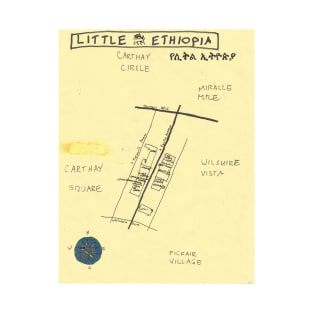
An ink and oil paint map of the Little Ethiopia neighborhood, in Midtown Los Angeles. I explored the enclave and made this map for "California Fool's Gold" in 2010. (https://ericbrightwell.com/2010/08/03/california-fools-gold-exploring-little-ethiopia-%E1%88%8A%E1%89%B5%E1%88%8D-%E1%8A%A2%E1%89%B5%E1%8B%AE%E1%8C%B5%E1%8B%AB/)
Tags: maps, art maps, midtown los angeles, los angeles neighborhoods, los angeles
Little Ethiopia
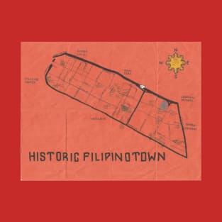
An ink and oil paint map of the Filipinotown neighborhood (officially known as "Historic Filipinotown") in Mideast Los Angeles (MELA) for "California Fool's Gold" in 2011. https://ericbrightwell.com/2011/05/13/california-fools-gold-exploring-filipinotown/
Tags: makasaysayang bayan ng pilipino, silver lake, filipinotown, echo park, hifi
Historic Filipinotown

I made this map as a thank you for a friend in a popular Glaswegian band... and to illustrate my account of visiting Glasgow in 2017.
Tags: cartography, glaschu, glesga, neighborhoods of glasgow, art maps
Glasgow

In 2018, I visited Japan for the first time. I always like to make a map of where I'm visiting -- even though there are obviously plenty of maps -- in part because helps me learn the geography of a place. https://ericbrightwell.com/2019/01/22/where-fools-fear-to-tread-a-snapshot-of-japan/
Tags: map art, art maps, maps, japanese, cartography
日本 Japan

An oil paint and ink map of the Montecito Heights neighborhood that I made in 2016 for "California Fool's Gold." https://ericbrightwell.com/2016/02/12/california-fools-gold-exploring-montecito-heights-the-wilderness-of-the-city/
Tags: los angeles, nela, los angeles neighborhoods, southern california, outsider art
Montecito Heights

An oil paint map of Miracle Mile that I did on commission. It was actually my first map pointed with oils -- in honor of the tar beneath the region.
Tags: mid wilshire, museum row, los angeles, la, midtown
Miracle Mile

An ink map that I did of Westwood for "California Fool's Gold." https://ericbrightwell.com/2018/04/21/california-fools-gold-exploring-westwood/
Tags: cartography, hand drawn map, westside, the westside, california
Westwood

An ink map of Koreatown I made for "California Fool's Gold" in 2010. For Los Angeles's most densely-populated neighborhood, I decided to go more minimal in a nod to Korean graphic design. https://ericbrightwell.com/2010/05/17/california-fools-gold-exploring-koreatown-%EC%BD%94%EB%A6%AC%EC%95%84%ED%83%80%EC%9A%B4/
Tags: la neighborhoods, neighborhoods, art maps, los angeles neighborhoods, los angeles
Koreatown

An ink and oil pain map I made of Yorba Linda for "California Fool's Gold." https://ericbrightwell.com/2016/07/07/california-fools-gold-exploring-yorba-linda-the-land-of-gracious-living/
Tags: cartography, oc, california, orange county, outsider art
Yorba Linda
I moved to Los Angeles in 1999. I couldn't find a map of all of the neighborhoods of the city. I set about making my own -- exploring the vast county on foot and mass transit. Along the way, I drew maps with ink and painted them in watercolors and oil paint -- or some combination (including correction fluid). As a lefty converted to a righty, my handwriting is terrible and my maps are sometimes hard to read when reproduced or reprinted -- and so I've made these clean, digital versions for people who prefer that sort of thing.
Tags: los angeles, la, so cal, los angeles neighborhoods, southern california
Los Angeles Neighborhoods

Watts is a neighborhood in South Los Angeles's Eastside. It's still best known for the Watts Towers (built 1921-1954 ) and the Watts Riots (1965). Lots has changed in the intervening half century, needless to say, and I explored and mapped in 2014 for my series, "California Fool's Gold" https://ericbrightwell.com/2014/02/14/more-than-just-riots-and-towers/
Tags: eastside, watts towers, hand drawn maps, art maps, los angeles neighborhoods
Watts

Compton is a city in the South Los Angeles region. It is the 7th oldest (by incorporation) and 16th most-populous in Los Angeles County. Future presidents George H.W. and George W. lived there in 1949 and '50. It is famous for the Compton Cowboys of Richland Farms and the Compton Cricket Club, among other things. I explored it and made this map in 2011 for my series, "California Fool's Gold." https://ericbrightwell.com/2011/02/23/california-fools-gold-exploring-compton-los-angeles-countys-hub-city/
Tags: south la, south los angeles, south central la, south central, hiphop
Compton

Orange County is typically divided into just two regions, North and South counties. South County is largely composed of gated, master-planned communities and other red tile suburbs. I painted this map and wrote a primer for my series, California Fool's Gold, in 2013.
Tags: irvine, hand drawn maps, newport beach, geography, the oc
South Orange County

The Northeast Los Angeles region is one of Los Angeles's oldest, dating back to the annexation of Garvanza, Highland Park, and Sycamore Grove in the late 19th century. I wrote a primer about the region for my series, "California Fool's Gold," in 2011 and made this map a bit later. https://ericbrightwell.com/2011/06/09/california-fools-gold-a-northeast-los-angeles-primer/
Tags: mount washington, atwater village, glassell park, eagle rock, highland park
Northeast Los Angeles

I explored and drew a map of Los Angeles County's second-largest city for my series, "California Fool's Gold," in 2011. https://ericbrightwell.com/2007/11/03/montebello-montesmello-if-youre-nasty/
Tags: los angeles neighborhoods, art maps, cartography, geography, la neighborhoods
Long Beach

This is the second map I made of Atwater Village. The first sold before I explored the neighborhood for "California Fool's Gold" in 2014. https://ericbrightwell.com/2014/11/30/california-fools-gold-exploring-atwater-village/
Tags: hand drawn maps, geography, cartography, california, la
Atwater Village

Angeleno Heights (originally "Angeleño Heights") is a mostly-residential Victorian-era suburb in Mideast Los Angeles (MELA). It's most famous for its grand Victorian homes (which is why it sometimes plays San Francisco in films and television) but there are also charming Crafstmans and homes in later styles. I explored for "California Fool's Gold" in 2010. https://ericbrightwell.com/2010/12/16/california-fools-gold-exploring-angeleno-heights/
Tags: hand drawn maps, la neighborhoods, los angeles neighborhoods, cartography, art maps
Angeleno Heights
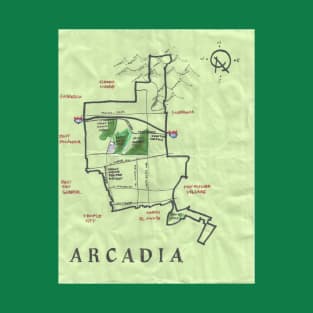
Arcadia is a suburb of the San Gabriel Valley which now has a population that is roughly two-thirds Asian-American (mostly Chinese and Taiwanese). It is thus often jokingly referred to as "Arcasia." I explored it in my series, "California Fool's Gold' in 2011. https://ericbrightwell.com/2011/01/04/california-fools-gold-exploring-arcadia-the-san-gabriel-valleys-community-of-homes/
Tags: arcadia, art maps, los angeles neighborhoods, los angeles neighborhoods map, maps
Arcadia
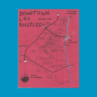
Downtown Los Angeles is a region of Central Los Angeles which is home to many small neighborhoods and districts. I explored and mapped it for my series, "California Fool's Gold," in 2011. https://ericbrightwell.com/2011/03/15/california-fools-gold-a-downtown-los-angeles-primer-2/
Tags: hand drawn maps, cartography, geography, california, neighborhood map
Downtown Los Angeles
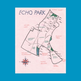
Echo Park is a neighborhood in Mideast Los Angeles (MELA) named after a park built around Echo Park Lake. I explored in 2010 for my series, "California Fool's Gold." https://ericbrightwell.com/2010/02/22/california-fools-gold-exploring-echo-park/
Tags: california fools gold, echo park, mela, mideast los angeles, la neighborhoods
Echo Park

Dayton Heights is a small neighborhood in Los Angeles. I explored it for California Fool's Gold and made this map as part of the process -- as seen on TV! https://ericbrightwell.com/2022/11/03/california-fools-gold-exploring-dayton-heights/
Tags: cartography, hollywood, los angeles, map, map art
Dayton Heights
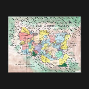
The San Gabriel Valley is one of the principal valleys of Metro Los Angeles. It's a fascinating region and I made a new map of it for a post about 626 Day (26 June), also known as San Gabriel Valley Day. https://ericbrightwell.com/2022/06/17/happy-626-or-san-gabriel-valley-day/
Tags: cartography, sgv, 626, california, fantasy cartography
The San Gabriel Valley

Pioneertown began life as a livable Western film set in 1946. When Westerns fell from fashion, Pioneertown fell on hard times. However, after the old Cantina reopened as a roadhouse (now Pappy & Harriets), things began to turn around and today Pioneertown is home to the Pioneertown Hotel, Red Dog Saloon, and other businesses -- and about 420 residents. https://ericbrightwell.com/2022/06/08/california-fools-gold-exploring-pioneertown/
Tags: california, cowboy, joshua tree, old west, wild west
Pioneertown
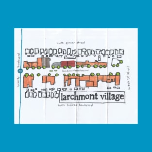
On Lunar New Year's Day of 2022, I visited the small Los Angeles neighborhood of Larchmont Village for my series, California Fool's Gold. https://ericbrightwell.com/2022/02/03/california-fools-gold-exploring-larchmont-village/
Tags: map, los angeles neighborhoods, art maps, larchmont, los angeles
Larchmont Village
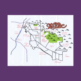
Whittier is a city in Southeast Los Angeles (County), separated from the San Gabriel Valley to the north by the Puente Hills and sharing a border with Orange County to the southeast. As of the 2020 Census, it had a population of 87,306, making it the 21st most populous city in Los Angeles County. It’s named after John Greenleaf Whittier, a Quaker, an abolitionist, and one of the so-called fireside poets. I explored it and drew this map for California Fool's Gold. https://ericbrightwell.com/2022/01/19/california-fools-gold-exploring-whittier/
Tags: art maps, los angeles neighborhoods, la, southeast los angeles, california
Whittier

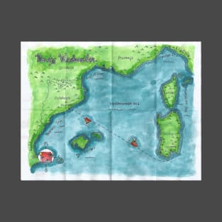
My watercolor and oil paint map of the Hawaiʻian islands, with their indigenous names (sorry "Midway"!) From my series, "Where Fool's Fear to Tread." https://ericbrightwell.com/2021/06/19/where-fools-fear-to-tread-a-snapshot-of-hawai%ca%bbi-o%ca%bbahu-and-kaua%ca%bbi/
Tags: hawaiian, hawaiian islands, hawaiian state, oahu, hawaiian culture
Hawaiʻi

Yucca Corridor is a neighborhood in the Hollywood region of Los Angeles. In the 1980s and 1990s, it was notorious for its crime. Today it's calmed down somewhat. https://ericbrightwell.com/2009/06/25/california-fools-gold-exploring-yucca-corridor/
Tags: art maps, yucca corridor, hollywood, map, cartography
Yucca Corridor

Santa Barbara is a resort town on California's Central Coast. I visited in 2020, before the COVID-19 pandemic hit, wrote about my visit for California Fool's Gold, and painted this map. https://ericbrightwell.com/2021/02/03/california-fools-gold-exploring-santa-barbara/
Tags: central coast, map, california, hand drawn map, cartography
Santa Barbara
In 2019, Belle & Sebastian organized a Mediterranean cruise featuring them and a whole host of other bands, including Camera Obscura, Teenage Fanclub, Tracyanne & Danny, the Vaselines, and Yo La Tengo, Buzzcocks, Alvvays, Campfire Social, Django Django, Elisabeth Elektra, Hinds, Honeyblood, Japanese Breakfast, Kelly Lee Owens, Nilüfer Yanya, Wet Look, Whyte Horses, and Wojtek the Bear. It was my first cruise -- and although I had a great time, quite possibly my last~ https://ericbrightwell.com/2019/10/14/where-fools-fear-to-tread-cruising-the-mediterranean-aboard-the-boaty-weekender/
Tags: mediterranean sea, mediterranean, cruise ship, cagliari, cruise