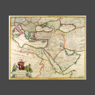
Antique map of the Turkish Empire and Ottoman Empire by Frederick de Wit featuring the Eastern Mediterranean, Greece, and Italy in the West and Saudi Arabia, the Persian Gulf and Caspian Sea in the east and centered on Turkey and Cyprus.
Tags:
europe, frederick de wit, maps, mediterranean, mercator
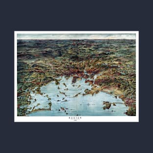
Bird's eye view of Boston and Environs from 1905. The map shows railroad routes and Boston waterways. Islands are labeled and lighthouses indicated. Vintage bird's eye view map of historic Boston Massachusetts and the landscape of the surrounding areas. Boston was founded in 1630, it is one of the oldest cities in the U.S. and played a key role in history in the American Revolution.
Tags:
american revolution, antique map, boston harbor, environs, landscape
Bird's eye view of Memphis, Tennessee in Shelby County 1870. Memphis was established along the high banks of the Mississippi River in the early 1800's. Memphis was an important cotton and lumber trading center in its early years.
Tags:
antique map, birds eye view, city map, landscape, mississippi river
Bird's eye view of Louisville, Jefferson County in Kentucky in 1876. Louisville was established in the late 1700's along the Ohio River. The river falls made it necessary to off-load riverboat cargo at this point until Beargrass Creek was formed into an alternate route. The early community prospered as a high bank riverfront trading center, with local farms producing wheat, oats, corn and many varieties of fruit for exportation. The salt trade was also very important in Louisville.
Tags:
antique map, city map, historic, history, jefferson county
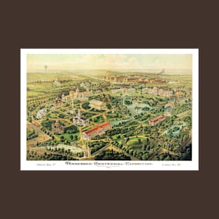
The Tennessee Centennial and International Exposition was an exposition held in Nashville, Tennessee from May 1 till October 31, 1897 in what is now Centennial Park.
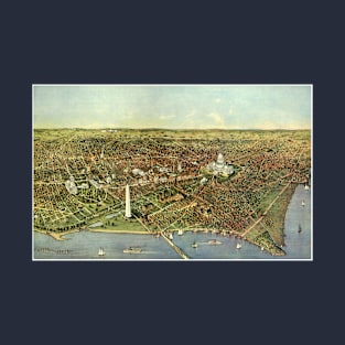
Vintage illustration bird's eye view of our nations Capitol, Washington DC in 1916. The Arlington Bridge crosses over the Potomac River, also seen is the Lincoln Memorial, the Washington Monument and the United States Capitol Building.
Vintage illustration antique map of London, England by Johannes de Ram, 1689. Londini Angliae Regni Metropolis Delineatio Novissima & Accuratissima Autore Ioanne De Ram. The map includes a 10 point key in the top left corner bearing the names of Southwark landmarks, and a 148 point key in the top-right with the names of locations on the other side of the Thames River. The smaller title contained in a classical cartouche; the arms of London with dragon supporters. The bottom right has portraits of William and Mary, along the bottom is a view of London and the Thames River shortly after the fire. The map celebrates King William III and Queen Mary II's ascent to the English throne after the Glorious Revolution.
Tags:
antique map, england, great britain, king william iii, landmarks
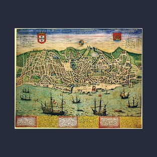
Vintage illustration antique Town Plan of Lisbon, Portugal, 1598 with ships in the harbor by topo-geographers and cartographers Georg Braun and Franz Hogenberg. Together they edited the Civitates orbis terrarum, which contains 546 prospects, bird's-eye views, and maps of cities from Europe and all around the world.
Tags:
antique map, capitol city, cartographers, city map, europe
Vintage illustration aerial antique street map featuring a town plan of the European city of Amsterdam, the Netherlands, in the northern province of Holland. By cartographer Gerardus Mercator, 1633. There are ships in the harbor, streets, buildings and a wall surrounding the city for protection. Decorative insets feature landmarks and buildings of interest.
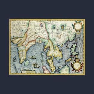
Vintage illustration antique South Asian map by Jodocus Hondius for the Gerardus Mercator Atlas, 1606. India Orientalis. This old world map of southeast Asia extends from India to the coasts of Southern China with the Pearl River Estuary, Canton and Formosa, it also includes all of the Malay peninsula and Indochina, northern Borneo and the Philippines, Japan and China. The decorative detail includes a large sea monster and an oriental junk in the Bay of Bengal as well as fine scroll work title and scale cartouches.
Tags:
antique maps, atlas, bay of bengal, borneo, cartouche
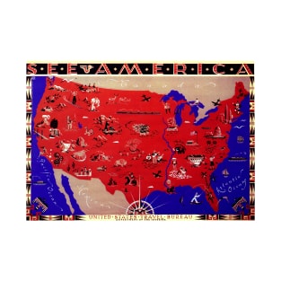
Vintage illustration antique map from the United States of America Travel Bureau, department of the interior. Many symbols across the map representing various regions. Also showing our border countries of Mexico and Canada. Titled "See America." A decorative border with Native American designs surrounds the map.
Tags:
antique map, canada, department of the interior, map, mexico
Vintage illustration bird's eye view of the streets of Saint Louis on the Mississippi River in 1859. St. Louis is a major U.S. port in the state of Missouri and is built along the western bank of the Mississippi River, on the border with Illinois. St. Louis was founded in 1764 by French fur traders Pierre Laclède and Auguste Chouteau, and named after Louis IX of France.
Tags:
aerial map, antique map, birds eye view, city map, mississippi river
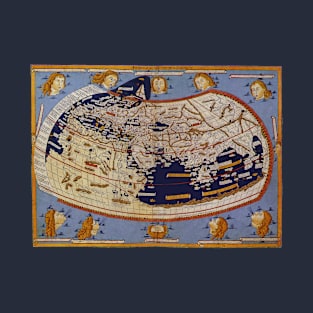
Vintage illustration antique old world map by Johannes Schnitzer von Arnsheim. This antique world map is part of famed cartographer Nicolaus Germanus’ wonderful rendition of Ptolemy’s ‘Cosmographia’ of 1482. The artist responsible for the woodcut map identifies himself at the top of the world map as Johannes of Arnsheim, making it the earliest datable printed map to have a signature.
Vintage illustration antique map of the City of Washington D. C. A bird's eye view from the Potomac River looking north. Originally published by Currier & Ives, 1892. Aerial view of several Washington DC landmarks including the Washington Monument and the Capitol Building. Ships and boats are sailing in the seaport harbor.
Vintage illustration antique world double hemisphere map Pieter Goos, 1666 featuring birds flying towards a shining sun casting rays over the hemispheres and continents. Below the chart is a set of allegorical figures representing the four seasons, summer, autumn, spring and winter. Orbis terrarum nova et accuratissima tabula.
Vintage illustration antique old world double hemisphere map by John Seller, 1673, originally published as part of his ‘Atlas Maritimus’, or A Book of Charts. Novissima Totius Terrarum Orbis Tabula. This map combines seasonal, zodiacal and symbolical scenes with astronomical diagrams and two pictures of the surface of the moon.
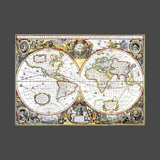
Vintage illustration 17th century antique map by Hendrik Hondius, 1630. Nova Totius Terrarum Orbis Geographica AC Hydrographica Tabula.
In addition to the hemispheres, continents and oceans, this old world map features portraits of Claudius Ptolemy, Gerardus Mercator, Jodocus Hondius Flander and Julius Caeser in the ornate decorative corners.
Vintage illustration antique old world double hemisphere map by Frederick de Wit (1629/30-1706). Terrarum Orbis.
This antique map features the Eastern and Western Hemispheres as well as the north and south poles. The baroque style illustrations in the corners represent the four elements: Fire with Pluto carrying off Persephone, attended by Cerberus, the three-headed guardian of Hades, as a battle scene rages in the background; Air as the heavenly realm ruled by Zeus and Hera, who are surrounded by winged creatures and other gods; Water with the sea god Neptune, mermen, a spouting whale, and sailing ships in the distance; and Earth represented by a scene with fauns presenting three goddesses with fruits of the harvest and livestock.
Vintage illustration antique world map featuring both hemispheres by Claude Auguste Berey, 1688 featuring the Eastern and Western Hemispheres, as well as, the north and south poles and all of the continents. Text boxes circle the hemispheres of this atlas, an ornate golden border decorates the edges and a decorative scroll is at the top.
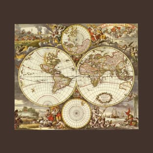
Vintage illustration antique world map by Frederick De Wit, 1668. Nova Totius Terrarum Orbis Tabula.
The double hemispheres feature the island of California and shorelines of western Australia and New Zealand, Southeast Asia, and includes Terra Esonis, the mythical land bridge which virtually connects Japan and California. The scenes surrounding the map are by Dutch artist Romeyn de Hooghe and represent the four elements. Fire is shown by war and destruction; air by the heavens; earth by harvesting and husbandry; and water by ships, a spouting whale and mermaids. There are groups of figures between the hemispheres and polar projection maps are above and below the atlas.
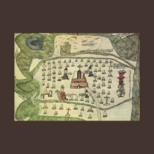
Vintage illustration antique world map featuring part of the Aztec Empire in central Mexico featuring a temple in the center probably used for human sacrifice. The church or temple is surrounded by a cemetery with gravestones and crosses. Circa 1577. Aztec refers to the Mexica people of Tenochtitlan, now the location of Mexico City.
Tags:
aztec empire, cemetery, church, human sacrifice, mexica
Vintage illustration antique world map featuring a view from the North Pole including the Arctic Circle, ocean and surrounding continents by Gerardus Mercator, 1595.
Vintage illustration antique world map detail by Martin Waldseemuller ( c. 1470-1520) featuring Amerigo Vespucci, an Italian explorer, navigator and cartographer. He is holding divider, which is used to measure distances on a map. The wind is blowing from the clouds.
Tags:
americas, antique maps, atlas, cartographer, explorer
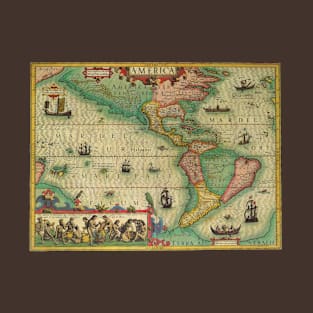
Vintage illustration 1596 antique world map featuring the Americas by Theodorus de Bry (1528-1598). America sive Novus Orbis, America or the New World, identifies North America as “America Mexicana” and South America as “America Peruana.” These geographical names reflect the late sixteenth-century dominance of Spanish power in the Americas. Four explorers reading maps to help the ships navigate and safely travel the seas surround the map.
Vintage illustration antique world map featuring the Americas, 1597 by Theodor de Bry. The map includes North, South and Central America, the Pacific and Atlantic Oceans and is surrounded by people, explorers in the four corners who are reading maps and helping ships to navigate and travel the world.
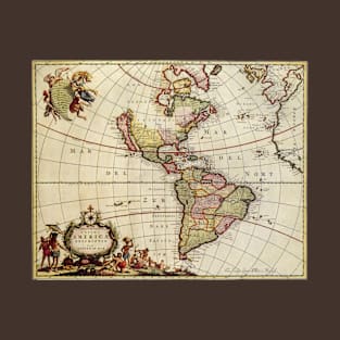
Vintage illustration antique map of the Americas by Johannes De Ram (1648-1693), c. 1685. A distinct characteristic of this map shows California as an island. The insert in the upper left includes some mythological figures with an angel, the insert in the lower left shows a scene with Natives.
Novissima et Accuratissima Totius Americae Descriptio per Ioannem De Ram
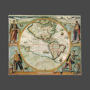
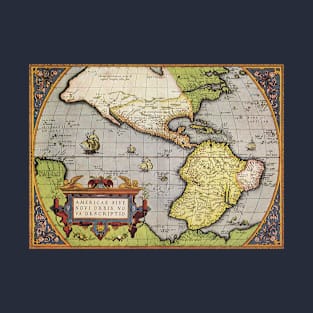
Vintage illustration antique world map of the Americas by Abraham Ortelius, 1570. Abraham Ortelius was a Flemish cartographer and geographer, generally recognized as the creator of the first modern atlas, the Theatrum Orbis Terrarum (Theatre of the World). He is also believed to be the first person to imagine that the continents were joined together before drifting to their present positions. A beautiful ornate cartouche with the title Americae Sive Novi Orbis No Va Sescriptio is in the corner.
Tags:
abraham ortelius, americas, antique maps, atlas, cartographers
Vintage illustration antique map featuring the city of Seattle, Washington by Augustus Koch, 1891. A view of Seattle and the surrounding area including Elliott Bay, Union Bay, Lake Washington and Lake Union.
Tags:
americana, augustus koch, elliott bay, lake union, lake washington
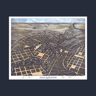
Vintage illustration bird's eye view of the streets of San Antonio, Texas in 1873 with the San Antonio River. The Alamo, an 18th-century Spanish mission preserved as a museum, marks an infamous 1836 battle for Texan independence from Mexico.
Vintage illustration bird's eye view of the streets of San Antonio, Texas in 1873 with the San Antonio River. The Alamo, an 18th-century Spanish mission preserved as a museum, marks an infamous 1836 battle for Texan independence from Mexico.
Tags:
aerial map, alamo, antique map, birds eye view, city
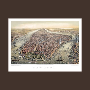
Vintage illustration map featuring an aerial landscape view of New York City and the Manhattan borough with the Brooklyn Bridge crossing over the East River with ships and boats sailing.
Tags:
antique map, brooklyn, brooklyn bridge, east river, harbor
Vintage illustration map featuring an aerial landscape view of New York City and the Manhattan borough with the Brooklyn Bridge crossing over the East River with ships and boats sailing.
Tags:
antique map, brooklyn, brooklyn bridge, east river, harbor
Vintage illustration bird's eye view map of Los Angeles, California, 1871 featuring views of the west coast with the Pacific Ocean, agricultural farm fields, buildings, streets and a variety if insets featuring daily life scenes and important landmarks.
Tags:
aerial map, agriculture, americana, antique map, california
Vintage illustration antique map of the City of Los Angeles California and the Santa Ana River. A bird's eye view as seen from the Electric Power House.