- Adult Apparel
- T-Shirts
- Tank Tops
- Hoodies
- Crewneck Sweatshirts
- Long Sleeve T-Shirts
- Baseball T-Shirts
- Kids Apparel
- Kids T-Shirts
- Kids Hoodie
- Kids Long Sleeve T-Shirt
- Home Goods
- Wall Art
- Mugs
- Pillows
- Totes
- Tapestries
- Pins
- Cases & Stickers
- Phone Cases
- Stickers
- Magnets

Beale St, Memphis, Tennessee, USA. Beale Street is a street in Downtown Memphis, Tennessee, which runs from the Mississippi River to East Street, a distance of approximately 1.8 miles (2.9 km). It is a significant location in the city’s history, as well as in the history of the blues. Today, the blues clubs and restaurants that line Beale Street are major tourist attractions in Memphis. Festivals and outdoor concerts periodically bring large crowds to the street and its surrounding areas.
Tags: vicki walsh, welcome, memphis, neon sign, vicki walsh photography
Beale St, Memphis, Tennessee, USA. Beale Street is a street in Downtown Memphis, Tennessee, which runs from the Mississippi River to East Street, a distance of approximately 1.8 miles (2.9 km). It is a significant location in the city’s history, as well as in the history of the blues. Today, the blues clubs and restaurants that line Beale Street are major tourist attractions in Memphis. Festivals and outdoor concerts periodically bring large crowds to the street and its surrounding areas.
Tags: vickiwalsh, vicki walsh, memphis bar, bar, juke joint

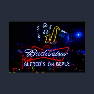
The Neon light at Dyers Burger Bar, Beale St, Memphis, Tennessee, USA. Beale Street is a street in Downtown Memphis, Tennessee, which runs from the Mississippi River to East Street, a distance of approximately 1.8 miles (2.9 km). It is a significant location in the city’s history, as well as in the history of the blues. Today, the blues clubs and restaurants that line Beale Street are major tourist attractions in Memphis. Festivals and outdoor concerts periodically bring large crowds to the street and its surrounding areas
Tags: vickiwalsh, burgers, vicki walsh photography, nightlife, vicki walsh

The Neon light at BB King's Blues Club, Beale St, Memphis, Tennessee, USA. Beale Street is a street in Downtown Memphis, Tennessee, which runs from the Mississippi River to East Street, a distance of approximately 1.8 miles (2.9 km). It is a significant location in the city’s history, as well as in the history of the blues. Today, the blues clubs and restaurants that line Beale Street are major tourist attractions in Memphis. Festivals and outdoor concerts periodically bring large crowds to the street and its surrounding areas.
Tags: memphis, tennessee, neon light, vickiwalsh, blues bar
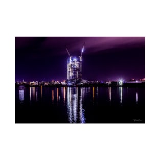
Victoria Harbour, Melbourne Docklands at night, Victoria, Australia. Whatever your mood, there's always something new to experience at Docklands. Escape for a while and discover Melbourne's spectacular harbour, just minutes from the city centre.
Tags: vicki walsh photography, water, reflections, australia, vickiwalsh
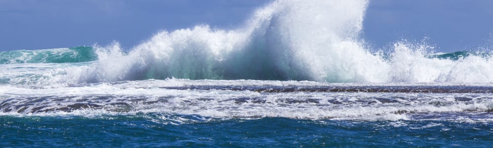
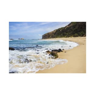
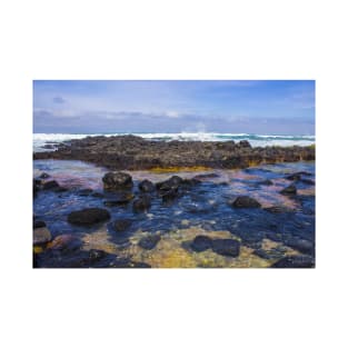
London Bridge, Portsea, Mornington Peninsula, Victoria, Australia. London Bridge is a well known, hollowed out sea stack that can be viewed from a lookout at the end of London Bridge Road. On either side of London Bridge are two high tide platform beaches, backed by 30 to 40 m high calcarenite bluffs and fronted by continuous intertidal rock flats, with reefs further offshore. Waves average 1.7 m on the outer reefs, with their height at the beach depending on the tide. The narrow sand beaches are awash at high tide, but fronted by exposed rock flats at low tide.
Tags: ocean beach, portsea, ocean, sunset, australia

London Bridge, Portsea, Mornington Peninsula, Victoria, Australia. London Bridge is a well known, hollowed out sea stack that can be viewed from a lookout at the end of London Bridge Road. On either side of London Bridge are two high tide platform beaches, backed by 30 to 40 m high calcarenite bluffs and fronted by continuous intertidal rock flats, with reefs further offshore. Waves average 1.7 m on the outer reefs, with their height at the beach depending on the tide. The narrow sand beaches are awash at high tide, but fronted by exposed rock flats at low tide.
Tags: water, vicki walsh photography, australia, vickiwalsh, sea

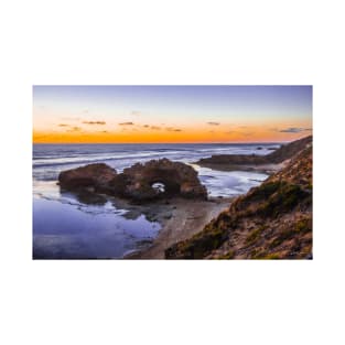
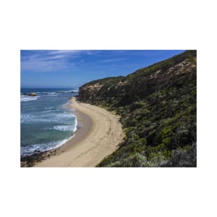
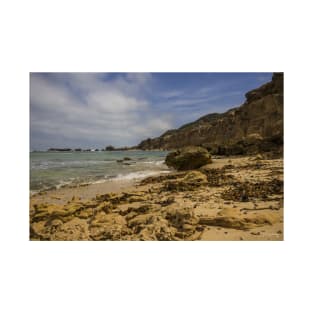
Fingal Beach, Cape Schanck, Mornington Peninsula, Victoria, Australia. The Fingal Beaches lie on the western side of Cape Schanck. They can be reached along the walking tracks from Cape Schanck and Fingal Picnic Area car parks. The two beaches are remnants of a once large beach, that supplied sand to the backing cliff-top dunes. Today they have been eroded down to the present strip of sand, fronted by rock platforms and reefs. They are backed by the 40 m high calcarenite cliffs with the active dunes on top.Both beaches face south-west into the full force of the westerly winds and waves. The waves break on the offshore reefs and rocks; and the narrow beaches are only active at high tide.
Tags: australia, vickiwalsh, mornington peninsula, cape schanck, vicki walsh photography

Fingal Beach, Cape Schanck, Mornington Peninsula, Victoria, Australia. The Fingal Beaches lie on the western side of Cape Schanck. They can be reached along the walking tracks from Cape Schanck and Fingal Picnic Area car parks. The two beaches are remnants of a once large beach, that supplied sand to the backing cliff-top dunes. Today they have been eroded down to the present strip of sand, fronted by rock platforms and reefs. They are backed by the 40 m high calcarenite cliffs with the active dunes on top.Both beaches face south-west into the full force of the westerly winds and waves. The waves break on the offshore reefs and rocks; and the narrow beaches are only active at high tide.
Tags: cape schanck, clouds, cliffs, vicki walsh, sea

London Bridge, Portsea, Mornington Peninsula, Victoria, Australia. London Bridge is a well known, hollowed out sea stack that can be viewed from a lookout at the end of London Bridge Road. On either side of London Bridge are two high tide platform beaches, backed by 30 to 40 m high calcarenite bluffs and fronted by continuous intertidal rock flats, with reefs further offshore. Waves average 1.7 m on the outer reefs, with their height at the beach depending on the tide. The narrow sand beaches are awash at high tide, but fronted by exposed rock flats at low tide.
Tags: sunrise, vicki walsh, sunset, ocean, australia

London Bridge, Portsea, Mornington Peninsula, Victoria, Australia. London Bridge is a well known, hollowed out sea stack that can be viewed from a lookout at the end of London Bridge Road. On either side of London Bridge are two high tide platform beaches, backed by 30 to 40 m high calcarenite bluffs and fronted by continuous intertidal rock flats, with reefs further offshore. Waves average 1.7 m on the outer reefs, with their height at the beach depending on the tide. The narrow sand beaches are awash at high tide, but fronted by exposed rock flats at low tide.
Tags: sunset, sunrise, australia, victoria, vicki walsh photography

Fingal Beach, Cape Schanck, Mornington Peninsula, Victoria, Australia. The Fingal Beaches lie on the western side of Cape Schanck. They can be reached along the walking tracks from Cape Schanck and Fingal Picnic Area car parks. The two beaches are remnants of a once large beach, that supplied sand to the backing cliff-top dunes. Today they have been eroded down to the present strip of sand, fronted by rock platforms and reefs. They are backed by the 40 m high calcarenite cliffs with the active dunes on top.Both beaches face south-west into the full force of the westerly winds and waves. The waves break on the offshore reefs and rocks; and the narrow beaches are only active at high tide.
Tags: ocean, rocks, clouds, sky, cape schanck

Fingal Beach, Cape Schanck, Mornington Peninsula, Victoria, Australia. The Fingal Beaches lie on the western side of Cape Schanck. They can be reached along the walking tracks from Cape Schanck and Fingal Picnic Area car parks. The two beaches are remnants of a once large beach, that supplied sand to the backing cliff-top dunes. Today they have been eroded down to the present strip of sand, fronted by rock platforms and reefs. They are backed by the 40 m high calcarenite cliffs with the active dunes on top.Both beaches face south-west into the full force of the westerly winds and waves. The waves break on the offshore reefs and rocks; and the narrow beaches are only active at high tide.
Tags: clouds, ocean, vicki walsh, rocks, vickiwalsh

Fingal Beach, Cape Schanck, Mornington Peninsula, Victoria, Australia. The Fingal Beaches lie on the western side of Cape Schanck. They can be reached along the walking tracks from Cape Schanck and Fingal Picnic Area car parks. The two beaches are remnants of a once large beach, that supplied sand to the backing cliff-top dunes. Today they have been eroded down to the present strip of sand, fronted by rock platforms and reefs. They are backed by the 40 m high calcarenite cliffs with the active dunes on top.Both beaches face south-west into the full force of the westerly winds and waves. The waves break on the offshore reefs and rocks; and the narrow beaches are only active at high tide.
Tags: ocean, blue sky, mornington peninsula, cape schanck, sky

Fingal Beach, Cape Schanck, Mornington Peninsula, Victoria, Australia. The Fingal Beaches lie on the western side of Cape Schanck. They can be reached along the walking tracks from Cape Schanck and Fingal Picnic Area car parks. The two beaches are remnants of a once large beach, that supplied sand to the backing cliff-top dunes. Today they have been eroded down to the present strip of sand, fronted by rock platforms and reefs. They are backed by the 40 m high calcarenite cliffs with the active dunes on top.Both beaches face south-west into the full force of the westerly winds and waves. The waves break on the offshore reefs and rocks; and the narrow beaches are only active at high tide.
Tags: ocean, mornington peninsula, cape schanck, beach, surf
Fingal Beach, Cape Schanck, Mornington Peninsula, Victoria, Australia. The Fingal Beaches lie on the western side of Cape Schanck. They can be reached along the walking tracks from Cape Schanck and Fingal Picnic Area car parks. The two beaches are remnants of a once large beach, that supplied sand to the backing cliff-top dunes. Today they have been eroded down to the present strip of sand, fronted by rock platforms and reefs. They are backed by the 40 m high calcarenite cliffs with the active dunes on top.Both beaches face south-west into the full force of the westerly winds and waves. The waves break on the offshore reefs and rocks; and the narrow beaches are only active at high tide.
Tags: sand, mornington peninsula, australia, clouds, cliff face
Fingal Beach, Cape Schanck, Mornington Peninsula, Victoria, Australia. The Fingal Beaches lie on the western side of Cape Schanck. They can be reached along the walking tracks from Cape Schanck and Fingal Picnic Area car parks. The two beaches are remnants of a once large beach, that supplied sand to the backing cliff-top dunes. Today they have been eroded down to the present strip of sand, fronted by rock platforms and reefs. They are backed by the 40 m high calcarenite cliffs with the active dunes on top.Both beaches face south-west into the full force of the westerly winds and waves. The waves break on the offshore reefs and rocks; and the narrow beaches are only active at high tide.
Tags: cliffs, blue sky, blue, beach, cape schanck

Fingal Beach, Cape Schanck, Mornington Peninsula, Victoria, Australia. The Fingal Beaches lie on the western side of Cape Schanck. They can be reached along the walking tracks from Cape Schanck and Fingal Picnic Area car parks. The two beaches are remnants of a once large beach, that supplied sand to the backing cliff-top dunes. Today they have been eroded down to the present strip of sand, fronted by rock platforms and reefs. They are backed by the 40 m high calcarenite cliffs with the active dunes on top.Both beaches face south-west into the full force of the westerly winds and waves. The waves break on the offshore reefs and rocks; and the narrow beaches are only active at high tide.
Tags: mornington peninsula, cliff face, beach, ocean beach, vicki walsh

Fingal Beach, Cape Schanck, Mornington Peninsula, Victoria, Australia. The Fingal Beaches lie on the western side of Cape Schanck. They can be reached along the walking tracks from Cape Schanck and Fingal Picnic Area car parks. The two beaches are remnants of a once large beach, that supplied sand to the backing cliff-top dunes. Today they have been eroded down to the present strip of sand, fronted by rock platforms and reefs. They are backed by the 40 m high calcarenite cliffs with the active dunes on top.Both beaches face south-west into the full force of the westerly winds and waves. The waves break on the offshore reefs and rocks; and the narrow beaches are only active at high tide.
Tags: ocean beach, rocks, cliffs, cliff face, beach
Fingal Beach, Cape Schanck, Mornington Peninsula, Victoria, Australia. The Fingal Beaches lie on the western side of Cape Schanck. They can be reached along the walking tracks from Cape Schanck and Fingal Picnic Area car parks. The two beaches are remnants of a once large beach, that supplied sand to the backing cliff-top dunes. Today they have been eroded down to the present strip of sand, fronted by rock platforms and reefs. They are backed by the 40 m high calcarenite cliffs with the active dunes on top.Both beaches face south-west into the full force of the westerly winds and waves. The waves break on the offshore reefs and rocks; and the narrow beaches are only active at high tide.
Tags: blue sky, rocks, australia, sky, ocean
Fingal Beach, Cape Schanck, Mornington Peninsula, Victoria, Australia. The Fingal Beaches lie on the western side of Cape Schanck. They can be reached along the walking tracks from Cape Schanck and Fingal Picnic Area car parks. The two beaches are remnants of a once large beach, that supplied sand to the backing cliff-top dunes. Today they have been eroded down to the present strip of sand, fronted by rock platforms and reefs. They are backed by the 40 m high calcarenite cliffs with the active dunes on top.Both beaches face south-west into the full force of the westerly winds and waves. The waves break on the offshore reefs and rocks; and the narrow beaches are only active at high tide.
Tags: sky, australia, beach, rocks, ocean

Fingal Beach, Cape Schanck, Mornington Peninsula, Victoria, Australia. The Fingal Beaches lie on the western side of Cape Schanck. They can be reached along the walking tracks from Cape Schanck and Fingal Picnic Area car parks. The two beaches are remnants of a once large beach, that supplied sand to the backing cliff-top dunes. Today they have been eroded down to the present strip of sand, fronted by rock platforms and reefs. They are backed by the 40 m high calcarenite cliffs with the active dunes on top.Both beaches face south-west into the full force of the westerly winds and waves. The waves break on the offshore reefs and rocks; and the narrow beaches are only active at high tide.
Tags: blue sky, mornington peninsula, sea, cliff face, victoria

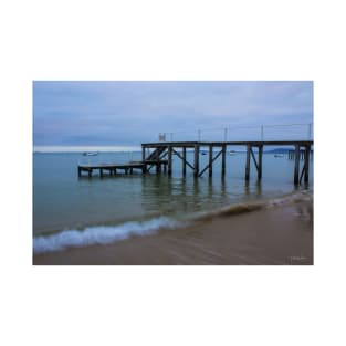
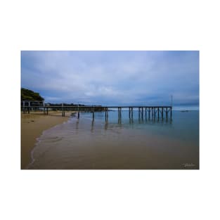
Sullivan Bay is the site of Victoria's first white settlement back in 1803. The settlement was located on the eastern point. The two calcarenite headlands that border the 400 m long bay are known as The Sisters. A foreshore reserve backs the western half of the bay and the historic section of the eastern Sister. Houses and some private jetties are located along the eastern half of the bay. There is a public parking area just off the Nepean Highway in the centre of the bay.The beach faces north-east and receives usually low wind waves. It consists of a relatively narrow strip of sand, fronted by 100 to 200 m wide tidal sand flats.
Tags: sea, jetty, victoria, mornington peninsula, smooth water
Sullivan Bay is the site of Victoria's first white settlement back in 1803. The settlement was located on the eastern point. The two calcarenite headlands that border the 400 m long bay are known as The Sisters. A foreshore reserve backs the western half of the bay and the historic section of the eastern Sister. Houses and some private jetties are located along the eastern half of the bay. There is a public parking area just off the Nepean Highway in the centre of the bay.The beach faces north-east and receives usually low wind waves. It consists of a relatively narrow strip of sand, fronted by 100 to 200 m wide tidal sand flats.
Tags: pier, beach, jetty, wave, bay

Sullivan Bay is the site of Victoria’s first white settlement back in 1803. The settlement was located on the eastern point. The two calcarenite headlands that border the 400 m long bay are known as The Sisters. A foreshore reserve backs the western half of the bay and the historic section of the eastern Sister. Houses and some private jetties are located along the eastern half of the bay. There is a public parking area just off the Nepean Highway in the centre of the bay.The beach faces north-east and receives usually low wind waves. It consists of a relatively narrow strip of sand, fronted by 100 to 200 m wide tidal sand flats.
Tags: vicki walsh, mornington peninsula, blue, sea, sorrento

Sullivan Bay, Sorrento, Mornington Peninsula, Victoria, Australia. Sullivan Bay is the site of Victoria's first white settlement back in 1803. The settlement was located on the eastern point. The two calcarenite headlands that border the 400 m long bay are known as The Sisters. A foreshore reserve backs the western half of the bay and the historic section of the eastern Sister. Houses and some private jetties are located along the eastern half of the bay. There is a public parking area just off the Nepean Highway in the centre of the bay.The beach faces north-east and receives usually low wind waves. It consists of a relatively narrow strip of sand, fronted by 100 to 200 m wide tidal sand flats.
Tags: smooth water, jetty, victoria, bay, sorrento
Sullivan Bay, Sorrento, Mornington Peninsula, Victoria, Australia. Sullivan Bay is the site of Victoria's first white settlement back in 1803. The settlement was located on the eastern point. The two calcarenite headlands that border the 400 m long bay are known as The Sisters. A foreshore reserve backs the western half of the bay and the historic section of the eastern Sister. Houses and some private jetties are located along the eastern half of the bay. There is a public parking area just off the Nepean Highway in the centre of the bay. The beach faces north-east and receives usually low wind waves. It consists of a relatively narrow strip of sand, fronted by 100 to 200 m wide tidal sand flats.
Tags: sorrento, waves, pier, ocean, blue

Sullivan Bay is the site of Victoria's first white settlement back in 1803. The settlement was located on the eastern point. The two calcarenite headlands that border the 400 m long bay are known as The Sisters. A foreshore reserve backs the western half of the bay and the historic section of the eastern Sister. Houses and some private jetties are located along the eastern half of the bay. There is a public parking area just off the Nepean Highway in the centre of the bay.The beach faces north-east and receives usually low wind waves. It consists of a relatively narrow strip of sand, fronted by 100 to 200 m wide tidal sand flats.
Tags: under the pier, smooth water, bay, under the jetty, pier
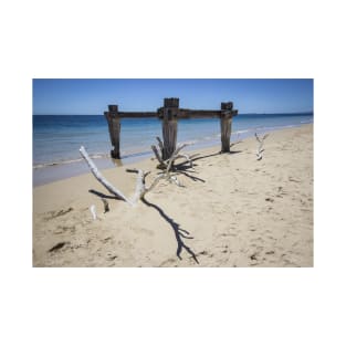
The old Cattle Jetty was built in 1879 to land cattle at the Point Nepean Quarantine station just inside Port Phillip Bay. Point Nepean marks the southern point of The Rip (the entrance to Port Phillip) and the most westerly point of the Mornington Peninsula, in Victoria, Australia.
Tags: jetty, water, sand, mornington peninsula, point nepean
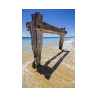
The old Cattle Jetty was built in 1879 to land cattle at the Point Nepean Quarantine station just inside Port Phillip Bay. Point Nepean marks the southern point of The Rip (the entrance to Port Phillip) and the most westerly point of the Mornington Peninsula, in Victoria, Australia.
Tags: sand, point nepean, observation point, sea, australia

Gog and Magog at the 12 Apostles, Port Campbell National Park, Victoria, Australia. The rugged splendour of the famous 12 Apostles, the magnificent rock stacks that rise up majestically from the Southern Ocean on Victoria's dramatic coastline. The limestone cliffs were created by constant erosion of the limestone cliffs of the mainland beginning 10–20 million years ago, the stormy Southern Ocean and blasting winds gradually eroded the softer limestone, forming caves in the cliffs. The caves eventually became arches and when they collapsed rock stacks up to 45 metres high were left isolated from the shore. View the 12 Apostles at sunrise and sunset as they change colour from dark and foreboding in shadow to brilliant sandy...
Tags: waves, limestone stacks, port campbell national park, surf, clouds
Gog and Magog at the 12 Apostles, Port Campbell National Park, Victoria, Australia. The rugged splendour of the famous 12 Apostles, the magnificent rock stacks that rise up majestically from the Southern Ocean on Victoria's dramatic coastline. The limestone cliffs were created by constant erosion of the limestone cliffs of the mainland beginning 10–20 million years ago, the stormy Southern Ocean and blasting winds gradually eroded the softer limestone, forming caves in the cliffs. The caves eventually became arches and when they collapsed rock stacks up to 45 metres high were left isolated from the shore. View the 12 Apostles at sunrise and sunset as they change colour from dark and foreboding in shadow to brilliant sandy yello...
Tags: australia, victoria, clouds, sunrise, waves

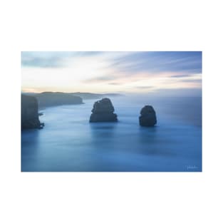
The 12 Apostles, Port Campbell National Park, Victoria, Australia. The rugged splendour of the famous 12 Apostles, the magnificent rock stacks that rise up majestically from the Southern Ocean on Victoria's dramatic coastline. The limestone cliffs were created by constant erosion of the limestone cliffs of the mainland beginning 10–20 million years ago, the stormy Southern Ocean and blasting winds gradually eroded the softer limestone, forming caves in the cliffs. The caves eventually became arches and when they collapsed rock stacks up to 45 metres high were left isolated from the shore. View the 12 Apostles at sunrise and sunset as they change colour from dark and foreboding in shadow to brilliant sandy yellow under a full su...
Tags: limestone stacks, water, blue, australia, victoria
The 12 Apostles, Port Campbell National Park, Victoria, Australia. The rugged splendour of the famous 12 Apostles, the magnificent rock stacks that rise up majestically from the Southern Ocean on Victoria's dramatic coastline. The limestone cliffs were created by constant erosion of the limestone cliffs of the mainland beginning 10–20 million years ago, the stormy Southern Ocean and blasting winds gradually eroded the softer limestone, forming caves in the cliffs. The caves eventually became arches and when they collapsed rock stacks up to 45 metres high were left isolated from the shore. View the 12 Apostles at sunrise and sunset as they change colour from dark and foreboding in shadow to brilliant sandy yellow under a full su...
Tags: magog, port campbell national park, long exposure, australia, victoria

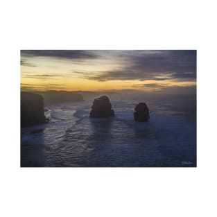
The 12 Apostles, Port Campbell National Park, Victoria, Australia. The rugged splendour of the famous 12 Apostles, the magnificent rock stacks that rise up majestically from the Southern Ocean on Victoria’s dramatic coastline. The limestone cliffs were created by constant erosion of the limestone cliffs of the mainland beginning 10–20 million years ago, the stormy Southern Ocean and blasting winds gradually eroded the softer limestone, forming caves in the cliffs. The caves eventually became arches and when they collapsed rock stacks up to 45 metres high were left isolated from the shore. View the 12 Apostles at sunrise and sunset as they change colour from dark and foreboding in shadow to brilliant sandy yellow under a full sun. ...
Tags: sunset, sky, clouds, coastline, water

The 12 Apostles, Port Campbell National Park, Victoria, Australia. The rugged splendour of the famous 12 Apostles, the magnificent rock stacks that rise up majestically from the Southern Ocean on Victoria’s dramatic coastline. The limestone cliffs were created by constant erosion of the limestone cliffs of the mainland beginning 10–20 million years ago, the stormy Southern Ocean and blasting winds gradually eroded the softer limestone, forming caves in the cliffs. The caves eventually became arches and when they collapsed rock stacks up to 45 metres high were left isolated from the shore. View the 12 Apostles at sunrise and sunset as they change colour from dark and foreboding in shadow to brilliant sandy yellow under a full sun...
Tags: clouds, waves, sky, gog, sunset